About The Photographer's Ephemeris
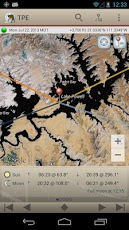
The Photographer's Ephemeris (TPE) helps to plan outdoor photography shoots. TPE is a map-centric sun and moon calculator: see how the light will fall on the land, be it day or night, for almost anywhere on earth. Our...
The Photographer's Ephemeris (TPE) helps to plan outdoor photography shoots.
TPE is a map-centric sun and moon calculator: see how the light will fall on the land, be it day or night, for almost anywhere on earth. Our Android app provides all the basic functionality you need to plan sun and moon photography.
Ideal for landscape, nature, travel and outdoor photographers, TPE's map-based approach means you can search for any place name on the planet or position the map pin exactly where you want it.
Advanced features include: automatic time zone and elevation detection, correction for atmospheric refraction and height above the horizon. You can even determine when the sun or moon will be visible from behind nearby hills and mountains.
Five map types are offered, including two topographic maps, ideal for landscape and nature photographers. Open Street Map and Open Cycle Map Topographic offer automatic offline support: any tiles you view are automatically cached for offline use.
Key features:
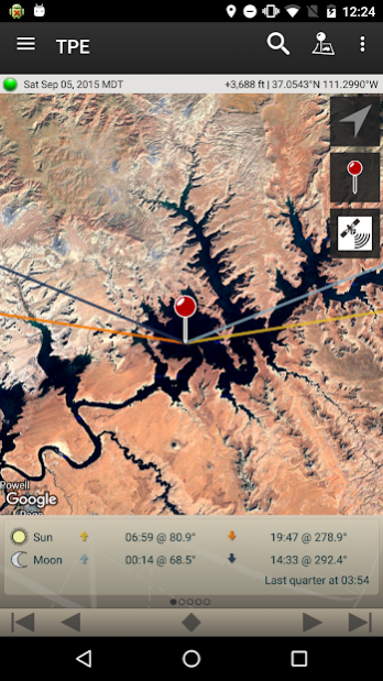
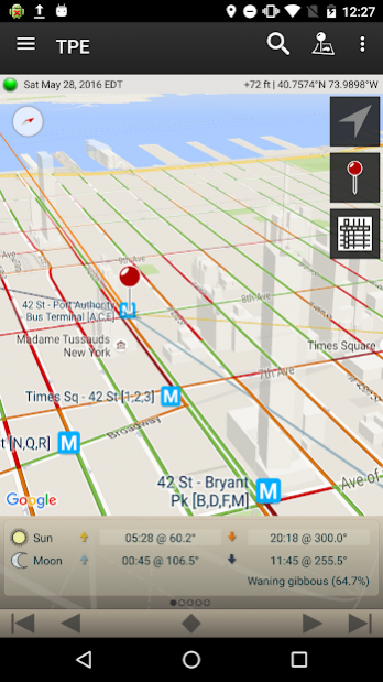
- Time and direction of sunrise and sunset
- Time and direction of moonrise and moonset
- Phase of the moon and % illumination
- Times of civil, nautical and astronomical twilight
- Graphical display on a map (Standard, Satellite/Hybrid, Terrain, Open Street Map, Open Cycle Map Topographic)
- Rotate and tilt the map for the optimal view
- Compass-based auto-rotation of the map
- Movable map pins - drag and drop the pin exactly where you need it
- Search for locations by address, place name, or enter coordinates directly
- Save any location you want - no fixed lists
- All features available in both portrait and landscape mode
- Does not require network connection for rise/set time, azimuths and sun/moon position
Advanced features:
- Automatic time zone detection for any location on earth
- Determines elevation above sea level
- View azimuth and altitude of sun/moon for any time of day/night
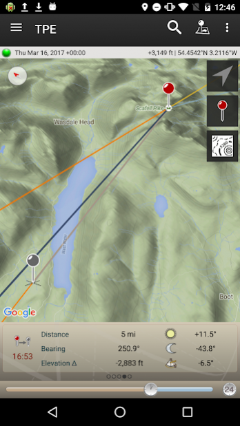
- Distance, bearing and elevation angle between any two points
- Import and export locations to/from KML
- Offline use with Open Street Map and Open Cycle Map Topographic maps
- Light pollution map overlay
- Reverse geocoding of coordinates
- Support for what3words three word address (more at https://ephemer.is/what3words)
Geek features:
- Find when the sun/moon will appear from behind a hill
- Compensation for atmospheric refraction
- Compensation for elevation above the horizon
Note:
- This app has a limited feature set relative to its iOS equivalent: please review this listing carefully to ensure that the features you need are included prior to purchasing
- Maps and elevation-based calculations require a data connection to function (execpt for Open Street Map and Open Cycle Map Topographic, which are cached to your device automatically)
- Locations outside ±80° latitude (very far north and south) are unsupported
- Map auto-rotate requires a compatible device (with magnetometer and accelerometer)
- Requires that you have Google Play Services and Google Maps installed on your device. Most devices already have both installed. TPE will prompt you to install these if they are missing.
End user license agreement: http://photoephemeris.com/android-eula
Please visit http://photoephemeris.com/support#android_support if you have any trouble installing Google Play Services.
TPE for desktop has been a favorite of photographers around the world for years. Now you can carry it with you.
Previous Versions
Here you can find the changelog of The Photographer's Ephemeris since it was posted on our website on 2014-06-13 23:25:50.
The latest version is 1.7.7 and it was updated on 2024-04-19 23:17:20. See below the changes in each version.
The Photographer's Ephemeris version 1.7.7
Updated At: 2020-12-01
Changes: - Fix for occasional KML import errors
- Updated SDKs and libraries
The Photographer's Ephemeris version 1.7.6
Updated At: 2020-02-05
Changes: - what3words: we now support what3words addresses - more below. what3words provides a unique three word address for any location on earth. Find out more at what3words.com
- Reverse geocoding: if you type a lat/lon coordinate into the search field, TPE now looks up nearby corresponding address and places
- Fixed: KML import
Please send your feedback and comments to
[email protected].
The Photographer's Ephemeris version 1.7.5
Updated At: 2019-11-06
Changes: - Improved coordinate parsing in the search page
You can paste a coordinate (lat/lon) directly into the search page. Multiple formats are now supported including decimal degrees (e.g. 46.2234° N, 6.1467° E), degrees/minutes/seconds (e.g. 46° 13' 24.24", 6° 8' 48.12"), and degrees plus decimal minutes (e.g. N46° 13.404', E6° 8.802').
Please send your feedback to
[email protected]
The Photographer's Ephemeris version 1.7.4
Updated At: 2019-11-01
Changes: - Updated address/place name search
- Paste a decimal coordinate into the search field to navigate there directly
- Map reticle added (tap to recenter pin)
Fixes
- Sun/moon azimuth lines appear after moving the map pin
- Display current location setting was sometimes not respected
- Units setting change is now reflected immediately in the UI
- Recentering the map pin placed it too far back if the map was tilted
- Updated SDKs
Please send your feedback to
[email protected]
The Photographer's Ephemeris version 1.7.2
Updated At: 2019-10-23
Changes: - Updated SDKs
Questions or feedback? Please write to us at
[email protected]
The Photographer's Ephemeris version 1.7.1
Updated At: 2019-04-23
Changes: - Change to using Thunderforest Transport map layer (for Open Street Map)
- Updated SDKs
Let us know if encounter any problems - please write to
[email protected].
The Photographer's Ephemeris version 1.6
Updated At: 2018-02-06
Changes: - New: Export Locations to KML
- Updated: Help documentation
- Updated: SDKs and Libraries
- Fix: invisible text in Search dialog
For support and questions, please contact us at
[email protected]
The Photographer's Ephemeris version 1.4.1
Updated At: 2016-07-11
Changes: 1.4.1 b79,- Fixes blank map on some new installs,- Other bug fixes,1.4 b77: new map types, with offline support,- Map type selection controls moved to map (was previously under Preferences),- Two new map types added: Open Street Map (OSM) and Open Cycle Map (OCM),- OSM and OCM automatically cached for 12 months for offline use (256MB cache size, subject to available storage),Suggestions, questions, comments, or problems? Write to us at
[email protected].
The Photographer's Ephemeris version 1.1.1
Updated At: 2013-02-14
Changes: Several fixes and updates
Disclaimer
Official Google Play Link
We do not host The Photographer's Ephemeris on our servers. We did not scan it for viruses, adware, spyware or other type of malware. This app is hosted by Google and passed their terms and conditions to be listed there. We recommend caution when installing it.
The Google Play link for The Photographer's Ephemeris is provided to you by apps112.com without any warranties, representations or guarantees of any kind, so access it at your own risk.
If you have questions regarding this particular app contact the publisher directly. For questions about the functionalities of apps112.com contact us.